
US Radar Quantum Imager Triple Frequency GPR

Sale Pre-Owned US Radar Quantum Imager Triple Frequency GPR System with Panasonic FZ-G1 Tablet. Fully tested, calibrated, and certified by authorized Trimble for performance.
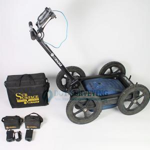
This US Radar Quantum Imager Triple Frequency GPR System bundled with the Panasonic FZ-G1 Rugged with US Radar Controller, making it a field-ready solution for professionals in utility locating, engineering, geology, construction, and archaeology.
The licenses with the US Radar Controller include the the Complete Acquisition: Desktop Mode, Data Storage, Internal GPS, Advanced & External GPS, Basic 3D, Advanced 3D, Google Earth, Basic Acquisition, Premium Acquisition, Auto-Report, Annotation, Tools, Complete. Includes a 6 month warranty and 14 days money back guarantee.
Includes:
- US Radar Quantum Imager Triple Frequency GPR System
- 2X Batteries for US Radar Quantum Imager
- 2X Battery Chargers
- Panasonic FZ-G1 Tablet with US Radar Controller Software Installed
- Panasonic FZ-G1 Tablet Charger
- Soft Carrying Case
Key Features and Specifications
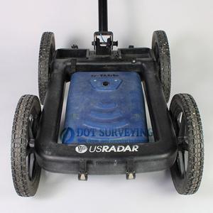
Triple-Frequency Antenna Technology
Unlike standard single-frequency GPRs, the Quantum Imager uses three separate frequencies simultaneously (250 MHz, 500 MHz, and 1000 MHz).
This allows users to view both deep and shallow targets in one scan, providing a complete subsurface picture with minimal post-processing.
Real-Time 3D Imaging
The integrated software and Panasonic FZ-G1 tablet provide real-time data visualization, enabling quick interpretation and accurate mapping of underground structures, pipes, and voids.
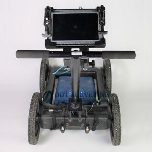
Rugged Panasonic FZ-G1 Tablet Integration
The included Panasonic Toughpad FZ-G1 runs the US Radar control software, designed to withstand harsh outdoor environments.
Key specs include:
- Intel Core i5 Processor
- Windows OS compatibility
- Sunlight-readable 10.1” touchscreen
- MIL-STD-810G certified durability
Mobility and Ease of Use
With its lightweight carbon fiber frame, adjustable handles, and modular design, the Quantum Imager offers exceptional portability for field projects.
Applications of the US Radar Quantum Imager
The Quantum Imager GPR system is widely used across various professional sectors:
| Application | Description |
|---|---|
| Utility Locating | Detects metallic and non-metallic utilities including pipes, cables, and conduits. |
| Concrete Scanning | Identifies rebar, post-tension cables, and voids within concrete slabs. |
| Archaeological Surveys | Maps ancient foundations, burial sites, and artifacts with non-destructive methods. |
| Environmental & Geological Studies | Examines soil layers, groundwater levels, and rock formations. |
| Engineering & Construction | Provides subsurface insight for pre-design and excavation projects. |