Radiodetection RD1500 GPR GPS


Radiodetection RD1500 GPR GPS for sale with GPS by Sensors & Software, RD1500 Enhanced Upgraded Version, Fully tested for functionality and everything is in good working condition
RD1500 Ground Penetrating Radar is Radiodetection's flagship GPR for utility locating.
The RD1500 provides all the great features of the RD1100 and also offers Depth Slices as well as Line Views. These allow the user to review slices of the subsurface at different depths, displaying cables, pipes and other utilities in unprecedented clarity. The RD1500 is designed to find buried pipes and cables. Features include internal GPS, on-board Wi-Fi, a high resolution touch screen as well as the proprietary FrequenSee technology which selectively enhances small/shallow, medium size/depth, or large/deep targets, or even all at once, for easier viewing and detection. Mini reports can be generated and delivered directly from the survey site by connecting to a Wi-Fi network or by using a cell phone as a hotspot. Data can also be exported to a USB memory stick.
Detect conductive and non-conductive pipes and ducts: Ground Penetrating Radar can detect ceramic and plastic pipes and ducts which would otherwise require tracer wire to detect using an electromagnetic locator.
FrequenSee ”3 Antennas in One”: FrequenSee selectively enhances small/shallow, medium size/depth, or large/deep targets, or even all, for easier viewing and detection. The proprietary FrequenSee™ technology exploits the wide bandwidth of the RD1500 antenna, and allows the user to select the low, medium or high part of the frequency spectrum to focus on the desired features. Systems incorporating FrequenSee are typically lighter and less bulky that competing multi-antenna alternatives.
Enhancement upgrade option: The Enhancement option for the RD1500, which includes the EKKO_Project software suite aids in the storage, export, interpretation and presentation of the collected data by enabling the user to: organise data into projects for increased storage on the RD1500; slice through the exported depth data; generate PDF reports that include data images, screenshots and photos alongside text and your company logo and export data to other formats like CSV and SEG-Y.
Internal Wi-Fi and USB for data transfer: Mini projects, containing screenshots and a table with information about the collected data, can be emailed immediately to clients or colleagues using the on-board Wi-Fi, either via a nearby wireless network or the user’s smart phone in hotspot mode. Screenshot images, and data for Enhancement system users, can also be exported to a USB drive for transfer to a computer or archive system.
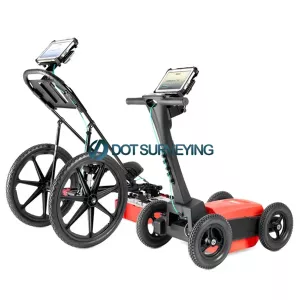
Rugged yet portable: Light-weight, rugged and weatherproof (IP65) system designed for use across challenging terrain. Optional larger wheels can be fitted to ease use across particularly soft or rough ground. The RD1500 can be assembled on-site in less than two minutes, and can be dismantled without requiring tools, allowing compact storage and safe transportation. Soft and hard cases are available for transportation of the display unit; alternatively an optional flight case can be used to protect the entire system.
Slice Views: By recording Grid Scans, users can view not only Line Views but also Depth Slices, greatly increasing the clarity of the collected data
GPS and Map View: The RD1500 includes internal GPS as standard, enabling the unique Map View feature that allows the user to view the path travelled by the system, together with any on-screen markers made. Users looking for higher accuracy positioning data can opt for the RD1500’s external GPS, which also enables the generation of KMZ files. These files can be opened in Google™ Earth™, giving all the geographic position of where saved surveys were performed and the ability to view the screenshots that were taken.
Additional analysis software options: EKKO_Project, included within the RD1500 Enhancement option, and Utility Suite are both available for the RD1500. See “Software” for
High resolution touch screen display: The high resolution Display Unit features touch screen operation, providing the user with the ability to draw arrows on the screen to highlight features of interest. Soil calibrations are simply done by dragging a Soil Cal Hyperbola to lie over a real hyperbola from the ground and matching the shape
Software: EKKO_Project Included within the RD1500 Enhancement option, EKKO_Project enables the user to: Organise data into projects for increased storage on the RD1500; slice through the exported depth data for increased clarity; generate PDF reports that include data images, screenshots and photos alongside the user’s text and company logo; and export data to other formats like CSV and SEG-Y
Utility Suite; For RD1500 Enhancement users, the Utility Suite software option offers an even more advanced analysis solution by providing three additional modules:
LineView module, which can modify the view settings to optimize the image and show data corrected for elevation; SliceView module for processing and displaying grid data as GPR lines and depth slices, and can output data into a 3D format for 3D visualization software such as Voxler® and; Interpretation module, which helps extract useful information from GPR data into other formats, such as CAD.
Options for the RD1500 include:
- an external GPS, for higher positional accuracy
- the Enhancement package, which enables the user to slice through the exported depth data, export data to other formats and more
- the Utility Suite software option offers features such as processing and displaying grid data in alternative ways, and the ability to output data to 3D visualization software such as Voxler
The RD1500 GPR system sets the highest standards for insights and target confidence to detect traditionally non-locatable subsurface features such as:
- Non-metallic pipes, including PVC and asbestos cement
- Underground electrical cable.
- Concrete storm and sewer systems.
- Metallic and non-metallic utilities.
- Utilities where installed tracer wiring has failed.
- Underground storage tanks and drainage tiles.
- Septic system components.
- Non-utility system structures such as vaults, foundation walls, and concrete pads.
Public utility systems and local governments require that the positions of underground systems be located and marked. This helps in planning projects and avoiding risks and hazards. The Radiodetection RD1500 builds on the capabilities of the RD1100 and adds further features to help you locate and map these utilities. It adds the powerful Grid Scan mode and the ability to use an external GPS to take full advantage of SplitView and MapView. The RD1500 Enhanced upgrade also allows data export for post-processing, archiving, reference and further mapping capabilities.
LMX200 Features
- Powerful touch screen display unit with line scan mode, grid scan, map view, and wi-fi on-site reports.
- US standard and metric options.
- Built-in Wi-Fi for direct share of display.
- USB port allows easy data transfer.
- Patented ultra-wideband 250 MHz GPR antenna and DynaT for dynamic target enhancement.
- Long-lasting lead acid gel battery.
- Collapsible, lightweight fiberglass cart frame for easy transport.
- Optional external GPS for higher accuracy geo-referencing of targets for post processing by CAS and GIS software.