


GSSI UtilityScan 350 HS Antenna
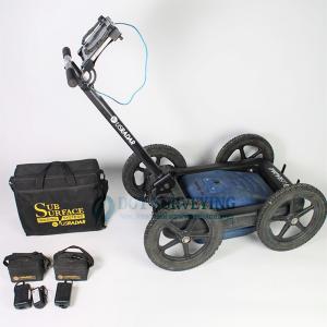
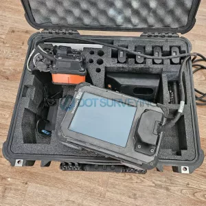
For sale GSSI UtilityScan 350 HS Antenna GPR System Optimized for Utility Locating included 350 HS antenna (350 MHz), Panasonic G2 Toughpad, 2 Year GSSI warranty
System sale Includes
- 350 HS antenna (350 MHz)
- Panasonic G2 Toughpad
- 2X Lithium-ion battery
- Dual-bay battery charger
- Rugged 2 m ethernet cable
- LineTrac, optional
- Sunshade for G2 Toughbook
- Quick Start Guide
- 2 Year GSSI warranty
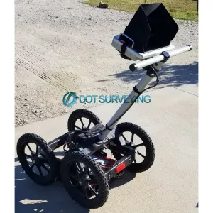
GSSI UtilityScan 350 HS Antenna GPR System
GSSI UtilityScan 350 HS Antenna GPR System provides a rich feature set that redefines the level of performance available in a low-cost utility locating system. The compact size makes it extremely portable and easy to manoeuvre in tight survey areas. The simple operation is ideally suited to meet the needs of service providers, engineering contractors and state and local municipalities. Best of all, the breakthrough technology designed into UtilityScan results in high quality data sets that are second to none.
Locating and marking underground utilities in real-time in the field has been a powerful application of ground penetrating radar (GPR) for many years. A knowledgeable utility locator with a GPR system as part of their toolbox is able to accurately identify buried utilities. UtilityScan is built for the utility locating professional to accelerate workflow from target detection to reporting.
Max Depth: 10 m (35 ft)
Antenna Frequency: 350 MHz
Weight with Tablet & Battery: 16.8 kg (37 lbs)
Storage Capacity: 512 GB
Optional Software: RADAN 7 for UtilityScan, RADAN 7
Accessories: Geode GPS, Transit case, Model 626 survey cart, Model 656 survey cart
The UtilityScan is typically used to:
- Scan utilities – metallic and non-metallic
- Locate water lines
- Detect voids and underground storage tanks (USTs)
- Identify soil and foundation characteristics
- Locate shallow objects for archaeology
Easily and accurately map utilities in real-time
Powerful mapping features, seamless sensor and GPS integration, and unmatched product reliability make the UtilityScan system an indispensable tool for utility locating professionals around the world.
 Real-Time Target Mapping
Map Mode allows users to trace their steps and gain a bird’s-eye view of their survey. Users can also simultaneously place American Public Water Association (APWA) color-coded marks on 2D data and a geo-referenced map. The on-screen 3D data collection mode allows users to easily define the time slice depth and thickness in the field with the 3D data on the screen. The map window can be minimized to view the 3D display full screen.
 Integrated Advanced Sensor
UtilityScan can be configured with an optional LineTrac® power detection module. LineTrac is designed to identify and trace the precise location of underground electric and RF-induced utilities. This allows the detected power or induced frequencies data to be overlaid on the radar data, providing reliable positioning and target information to the user. These technologies are integrated into one seamless system to aid in target recognition and mapping, a first for the utility detection industry.
 Rugged System for Construction Environments
UtilityScan is rated IP65 and built to meet your job site needs. It can withstand the most challenging survey environments including rain, dust, and extreme cold down to -20°C (-4°F). The Panasonic G2 tablet screen is designed for rain and glove use. For areas where Wi-Fi is prohibited, this system includes a rugged Ethernet cable that can be used for communication between the tablet and antenna.
Data Examples
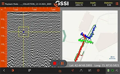 Real-Time Target Mapping
With Map Mode on UtilityScan, you can simultaneously pick targets and view their corresponding location on the GIS map shown on the right side of the screen. You can select the window size of the data and the map, or keep it split evenly as shown. The map in this data example shows an overview where the user located three different types of utilities. The dark green line represents the path that was taken when collecting the data.
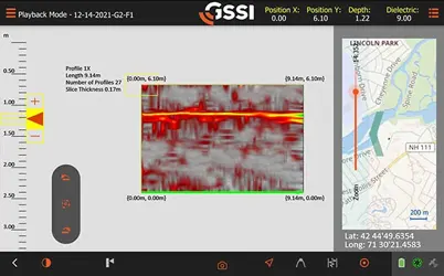 3D Image
On-screen 3D data collection mode allows you to define an area of interest. You can easily define the time slice depth and thickness in the field with the 3D data on the screen. The map window can be minimized to view your 3D display full screen.
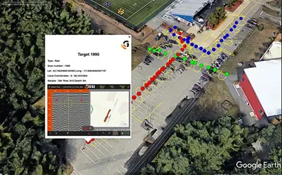 Satellite & Aerial Imagery
UtilityScan software automatically saves a sample image (Target 1990 in this example) for every target designated within the software. These in-field targets can easily be exported into commonly available geo-browsers. These browsers can be used to create images for reports in the office or in the field.
Specifications
| Display | 10.1” WUXGA 1920 x 1200 Capacitive gloved multi touch + digitizer |
| Environmental Rating | IP65 (tablet dependent) |
| Display Modes | Linescan, Map, 3D and Focus Mode |
| Data Collection Speed | < 3.5 mph (6.5 km/h) |
| Operating Temperature | -20° C to 40° C (-4° F to 104° F) |